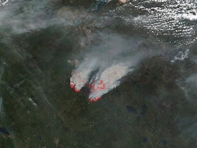
Fort McMurray fire sends up huge columns of smoke
NASA's Suomi NPP satellite collected this natural-color image using the VIIRS (Visible Infrared Imaging Radiometer Suite) instrument on May 16, 2016. The actively burning areas are outlined in red.
The fire north of Fort McMurray had retreated and some citizens had returned, but in the last few days this area has been threatened again.
On May 15, warnings were issued that the wildfire was moving at 30-40 meters (98-131 feet) per minute to the north again.
The smoke released by any type of fire (forest, brush, crop, structure, tires, waste or wood burning) is a mixture of particles and chemicals produced by incomplete burning of carbon-containing materials. All smoke contains carbon monoxide, carbon dioxide and particulate matter (PM or soot). Smoke can contain many different chemicals, including aldehydes, acid gases, sulfur dioxide, nitrogen oxides, polycyclic aromatic hydrocarbons (PAHs), benzene, toluene, styrene, metals and dioxins, read the NASA webiste.
The type and amount of particles and chemicals in smoke varies depending on what is burning, how much oxygen is available, and the burn temperature. The air pollution levels in and around Alberta remain at dangerously high levels. Current readings show it to be at 38 where 10 is considered dangerously high.
NASA image courtesy Jeff Schmaltz LANCE/EOSDIS MODIS Rapid Response Team, GSFC. Caption by Lynn Jenner
Support Our Journalism
We cannot do without you.. your contribution supports unbiased journalism
IBNS is not driven by any ism- not wokeism, not racism, not skewed secularism, not hyper right-wing or left liberal ideals, nor by any hardline religious beliefs or hyper nationalism. We want to serve you good old objective news, as they are. We do not judge or preach. We let people decide for themselves. We only try to present factual and well-sourced news.


